Nebraska and Iowa
Introduction:
Nebraska and Iowa, nestled in the heart of the American Midwest, are no strangers to the capricious whims of Mother Nature. From the expansive plains to the rolling hills, these states experience a diverse array of weather phenomena throughout the year. Among the most formidable are storms, which can unleash their fury with little warning, leaving a trail of destruction in their wake. Understanding the dynamics of storm weather in Nebraska and Iowa is not only crucial for residents but also for emergency preparedness efforts and the broader scientific community. In this comprehensive exploration, we delve into the intricacies of storm weather in these two states, shedding light on their causes, impacts, and measures to mitigate their adverse effects.
- The Dynamics of Storm Formation:
Storms in Nebraska and Iowa can arise from a myriad of atmospheric conditions, but one of the primary catalysts is the clash between contrasting air masses. In the spring and summer months, warm, moisture-laden air from the Gulf of Mexico collides with cooler, drier air from the north, setting the stage for the formation of severe thunderstorms and tornadoes. This clash of air masses creates instability in the atmosphere, leading to the rapid uplift of warm air and the formation of towering cumulonimbus clouds. - Tornado Alley: Understanding Tornadoes in the Heartland:
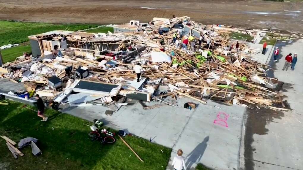
Nebraska and Iowa are part of the infamous “Tornado Alley,” a region in the central United States known for its high frequency of tornadoes. Tornadoes, characterized by violently rotating columns of air extending from thunderstorms to the ground, pose a significant threat to life and property in these states. While tornadoes can occur at any time of the year, they are most common during the spring and early summer months when atmospheric conditions are most conducive to their formation. - Impact on Agriculture:
The agricultural sector forms the backbone of Nebraska and Iowa’s economies, and stormy weather can have profound implications for farmers and ranchers. Severe storms, accompanied by hail, high winds, and torrential rainfall, can devastate crops, flatten fields, and damage infrastructure such as barns and silos. Furthermore, prolonged periods of excessive rainfall can lead to waterlogged soils, delaying planting and harvesting operations and reducing crop yields. The economic toll of storm damage on the agricultural industry can be staggering, with billions of dollars lost annually. - Flood Risk and Management:
Flooding is another significant concern associated with storm weather in Nebraska and Iowa. The region’s extensive network of rivers, including the Missouri, Platte, and Cedar rivers, is susceptible to overflowing during periods of heavy rainfall or rapid snowmelt. Urban areas, agricultural land, and infrastructure situated along riverbanks are particularly vulnerable to flooding, posing risks to public safety and exacerbating property damage. Effective flood risk management strategies, including levees, floodplain zoning, and early warning systems, are essential for mitigating the impacts of inundation. - Preparedness and Response Efforts:
Given the unpredictable nature of storms, preparedness and response efforts are paramount for safeguarding lives and property in Nebraska and Iowa. State and local authorities work tirelessly to educate the public about storm safety procedures, disseminate timely weather alerts, and coordinate emergency response activities. Community resilience is strengthened through initiatives such as storm shelters, emergency evacuation plans, and community emergency response teams. Additionally, advancements in meteorological technology, such as Doppler radar and satellite imagery, enable forecasters to provide more accurate and timely warnings, enhancing the effectiveness of preparedness efforts.
FAQs:
- What is the peak season for storms in Nebraska and Iowa?
The peak season for storms, including tornadoes, in Nebraska and Iowa typically spans from late spring to early summer, although severe weather can occur throughout the year. During this time, the clash between warm, moist air from the Gulf of Mexico and cooler, drier air from the north creates favorable conditions for storm formation. - How can residents prepare for severe storms?
Residents can prepare for severe storms by staying informed about weather forecasts and warnings, creating a family emergency plan, and assembling a disaster supply kit. It’s also essential to identify safe shelter locations, such as basements or interior rooms on the lowest floor of a sturdy building, and practice tornado drills regularly. - What measures are in place to mitigate flood risk in Nebraska and Iowa?
To mitigate flood risk, Nebraska and Iowa implement a range of measures, including levees, floodplain zoning regulations, and reservoir management. Additionally, state and local authorities invest in flood forecasting and warning systems to provide timely alerts to at-risk communities and coordinate emergency response efforts. - How does stormy weather impact transportation infrastructure?
Stormy weather, including heavy rainfall, high winds, and tornadoes, can disrupt transportation infrastructure in Nebraska and Iowa. Flooded roads, downed trees, and debris on highways can impede travel, while damage to bridges and overpasses may require repairs before routes can be reopened. - What role do agricultural practices play in mitigating storm impacts?
Agricultural practices such as conservation tillage, contour farming, and the use of cover crops can help mitigate the impacts of storms on farmland. These practices promote soil health, reduce erosion, and enhance water infiltration, making agricultural land more resilient to heavy rainfall and flooding. Additionally, crop insurance programs provide financial protection for farmers against losses caused by storm damage.

